prince of persia
beyblade draciel
robot gripper
toko fukawa
gaming room
thrustmaster 599xx
slayer
letterpress printing
xiaomi m365 pro battery
pumpmaster 760
screen monitor diy
army dog tag
scuba hose
pirate belt buckle
cardboard train
nail cartier model
monkey king helmet
logitech k120
pizza planet rocket
ice princess
hejne
zombicide character
dremel stylo holder
incra jig
pole extension
Free
Myminifactory
JBonasera
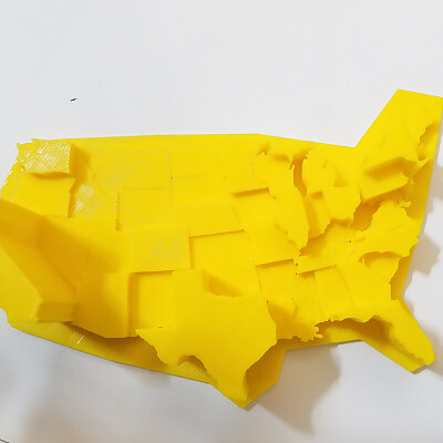
United States Electoral College Height Map
I first created this file in August of 2016 and I suppose its starting to become relevant again Each states electoral votes are represented as height At full scale its 1 vote 1mm The slight gap between the states provides a visible ...
— Go to Myminifactory
similar models —
United States Electoral College Height Map alternatives
KurtM88
United States Interstate Highway System
KurtM
United States Interstate Highway System
MakingThingsCLT
Electoral College Map
1585
United States of America 3D Map 3D model
anoved
Contiguous United States Prism Map
AndrewKreczko
Map Of The United States
TheNewHobbyist
Customizable USA Electoral College Map
Brainrelates
'1 PERSON = 1 VOTE' necklace charm with 1 ring
PhD3DP
US map keychain (separate states)
2ROBOTGUY
.50 Caliber BMG Bullet
Find more